CLIMATE JUSTICE
-
-

This image presented in Congress was influential toward passage of our nation’s first legislation to regulate methane gas, a key constituent of the greenhouse gases that accelerate climate change. What appears as a fire-breathing dragon is an open flare pit near the Fort Berthold Indian Reservation, burning off natural gas vented during fracking’s penetration of the earth’s crust. Private oil and gas installation leased near Fort Berthold Indian Reservation, North Dakota.
-

Photography to support great analysis by philosopher Kathleen Dean Moore in High Country News
-

Note the rust-colored swath of dead vegetation in the foreground. This is the path of the estimated one-million-gallon-plus fracking wastewater pipeline leak as it spilled into the drainage leading to Bear Den Bay and Lake Sakakawea. Bear Den Bay is seen branching off the lake in the upper left of the photograph. This is the land of the Three Affiliated Tribes on the Fort Berthold Indian Reservation, North Dakota. Effluent from this July 2014 underground spill flowed from Bear Den Bay to the freshwater intake for the nearby community of Mandaree. Drilling platforms placed near the shores of Lake Sakakawea increase the reach of fracking "laterals" that travel up to four miles horizontally in all directions. Roads fragment the natural landscape. The photographer assisted Tribal Members with aerial photography and collection of water samples for analysis by the EPA. Photograph by Bruce Farnsworth with the support of Lighthawk.
-

This pond is located in the Bear Ben Bay drainage which was impacted by a massive wastewater leak in July 2014. The spill is located upstream from the water intake of the community of Mandaree. Bakken oil activities on the Fort Berthold Indian Reservation, North Dakota. Water samples collected by Tribal members and the photographer were sent to Duke University for testing that confirmed wastewater toxins.
-
 on the Fort Berthold Reservation, smells wild bergamot (Monarda fisutlosa) while holding a bundle of silver sage (Artemesia cana) collected near site of 2014 Arrow pipeline spill which contaminated a drainage above Bear Den Bay on Lake Sakakawea with over a million gallons of fracking wastewater. Vance is collecting plants on the hills above the drainage. The plant stem in Mr. Gillette's hand crosses an orange object in the background. That's a pump placed by an industry contractor to pull out contaminated water that collected above a beaver dam in the impacted drainage. Gillette is family of the late Russell Gillette, who was forced by the Department of the Interior in 1953 to sign away the rich agricultural bottomlands of the upper Missouri River valley prior to the construction of the Garrison Dam which fllooded much of Three Affiliated Tribe land.")
Vance Gillette, environmental attorney and founding member of Save Our Aboriginal Resources (SOAR) on the Fort Berthold Reservation, smells wild bergamot (Monarda fisutlosa) while holding a bundle of silver sage (Artemesia cana) collected near site of 2014 Arrow pipeline spill which contaminated a drainage above Bear Den Bay on Lake Sakakawea with over a million gallons of fracking wastewater. Vance is collecting plants on the hills above the drainage. The plant stem in Mr. Gillette's hand crosses an orange object in the background. That's a pump placed by an industry contractor to pull out contaminated water that collected above a beaver dam in the impacted drainage. Gillette is family of the late Russell Gillette, who was forced by the Department of the Interior in 1953 to sign away the rich agricultural bottomlands of the upper Missouri River valley prior to the construction of the Garrison Dam which fllooded much of Three Affiliated Tribe land.
-
 totaled more than 12.5 million acres and stretched from the Canadian border to the Powder River of Wyoming. When the Garrison Dam inundated the Missouri River floodplains in 1954, Native communities lost more than half of their fertile agricultural bottomlands. The tribe protested, \"the lands which will be flooded are practically all the lands which are of any use or value.\" Native people were forced to re-bury their own on higher ground. These are relocated Mandan graves on the tablelands above the river.")
To title this gallery as fracking photographs offer only the context of modern industrialization. These are stories of deep Native and cultural connections to the land. Wave of oppression and transformation met with resilience and perseverance. The Sky, Earth and Water of the Missouri River valley and the lifeways of the Original People are now facing a largely unregulated oil and gas industry. In the Fort Laramie Treaty of 1851, the land of the Three Affiliated Tribes (Mandan, Hidatsa and Arikara) totaled more than 12.5 million acres and stretched from the Canadian border to the Powder River of Wyoming. When the Garrison Dam inundated the Missouri River floodplains in 1954, Native communities lost more than half of their fertile agricultural bottomlands. The tribe protested, "the lands which will be flooded are practically all the lands which are of any use or value." Native people were forced to re-bury their own on higher ground. These are relocated Mandan graves on the tablelands above the river.
-

Native youth in conversation before dance events at the Mandaree Powwow. The headdress of Eagle feathers and Porcupine quills represents connections to sky and land. Fort Berthold Reservation, North Dakota.
-
 is also known as the American buffalo. These majestic animals can be seen in Yellowstone National Park and here, at Theodore Roosevelt National Park in North Dakota. Bison once roamed in herds tens of thousands strong across the North American plains but were decimated in the 19th century by relentless commercial hunting and, later, by the introduction of disease from modern cattle.They are now restricted to a few protected areas, as well as captive herds maintained for farming and private hunting. The American bison's historical range formed a massive triangle across North American, from the Great Bear Lake in Canada's northwest, south to the Mexican states of Durango and Nuevo León, and east to the U.S. Atlantic coast going as far south as Georgia or Florida.")
The American Bison or Plains bison (Bison bison bison) is also known as the American buffalo. These majestic animals can be seen in Yellowstone National Park and here, at Theodore Roosevelt National Park in North Dakota. Bison once roamed in herds tens of thousands strong across the North American plains but were decimated in the 19th century by relentless commercial hunting and, later, by the introduction of disease from modern cattle.They are now restricted to a few protected areas, as well as captive herds maintained for farming and private hunting. The American bison's historical range formed a massive triangle across North American, from the Great Bear Lake in Canada's northwest, south to the Mexican states of Durango and Nuevo León, and east to the U.S. Atlantic coast going as far south as Georgia or Florida.
-
 is a rodent of the Northern Great Plains of North America. They don't actually hibernate but remain active below ground during the coldest months, coming topside by midwinter. Feeding on grasses and seeds, they are vulnerable to toxins in the soil and contaminated runoff. The black-tailed prairie dog was described by the Lewis and Clark Expedition in their expedition diaries.")
The Black-tailed prairie dog (Cynomys ludovicianus) is a rodent of the Northern Great Plains of North America. They don't actually hibernate but remain active below ground during the coldest months, coming topside by midwinter. Feeding on grasses and seeds, they are vulnerable to toxins in the soil and contaminated runoff. The black-tailed prairie dog was described by the Lewis and Clark Expedition in their expedition diaries.
-
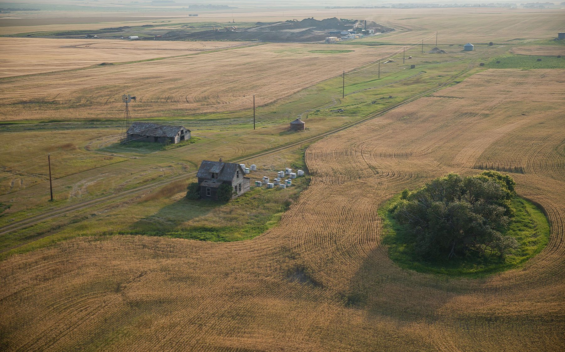
, a massive array of crude oil storage tanks and 14 pump-jacks indicate this location is far from the hub of oil operations on the Bakken oil formation. Oil and wastewater must be stored until trucks can haul it away. Plans are underway to build a bridge near this location that will carry traffic to the community of Twin Buttes. Ever since Garrison Dam was built, Twin Buttes has been isolated. A bridge may bring more public services, but it will also induce a surge in oil and gas activity and settlement. Aerial photography by Bruce Farnsworth supported by LightHawk.")
On the north shore of Lake Sakakawea (Native name for that section of the Missouri River flooded by the U.S. Department of the Interior with the installation of the Fort Garrison Dam in 1954), a massive array of crude oil storage tanks and 14 pump-jacks indicate this location is far from the hub of oil operations on the Bakken oil formation. Oil and wastewater must be stored until trucks can haul it away. Plans are underway to build a bridge near this location that will carry traffic to the community of Twin Buttes. Ever since Garrison Dam was built, Twin Buttes has been isolated. A bridge may bring more public services, but it will also induce a surge in oil and gas activity and settlement. Aerial photography by Bruce Farnsworth supported by LightHawk.
-
-

A farmer in Bottineau county, North Dakota found this crude bubbling to the surface while seeding his field for radishes. Abandoned oil field debris on the surface indicate this was a pipeline leak. The North Dakota State Department of Public Health visited the site, but has not indicated any plans for remediation.
-

Unharnessed gas flares burning into the atmosphere, like this one behind an abandoned one-room schoolhouse near Keane, North Dakota, dot the five counties of petroleum development on the Bakken Formation of western North Dakota.
-

Radioactive filter socks. These nylon mesh filters are used where tanker trucks offload fracking wastewater. The wastewater passes through these filters before it is pumped into large storage tanks. Production water, injected deep in the earth's crust to break displace trapped oil deposits, contains sands and several hundred toxic chemicals including as many as a dozen carcinogens. Both this wastewater, and the "blowback" water that returns when a wellbore is drilled, make up the effluents that are filtered. Production water also brings radioactivity. The allowable level of radioactivity for any item disposed in a public landfill is 5 picocuries in North Dakota: each sock may register between 80-350 pico-curies of radioactivity and current regulations call for this radioactive waste to be disposed in one of a few specially-designed landfills in the U.S. Fracking socks have been disposed of improperly in abandoned buildings. I photographed these filter socks as they were placed in conventional trash cans.
-
 gas levels and sound an alert if dangerous. Every two months, he flies to Los Angeles to visit his wife and five kids for ten days. His work pays their rent in a small apartment. While he lamented he would never have the opportunity to attend college, he is glad that his work will allow him to give his children that chance. He has applied for citizenship and expects to be naturalized into the U.S. very soon.")
Vic is an oil worker who came from Kenya several years ago, winner in a lottery for work visas. He's a truck driver, carrying loads of toxic production and blowback fluids on the Bakken oil fields and disposing of wastewater at stations like this one. The yellow meter on his lapel is designed to monitor ambient levels of hydrogen sulfide (H2S) gas levels and sound an alert if dangerous. Every two months, he flies to Los Angeles to visit his wife and five kids for ten days. His work pays their rent in a small apartment. While he lamented he would never have the opportunity to attend college, he is glad that his work will allow him to give his children that chance. He has applied for citizenship and expects to be naturalized into the U.S. very soon.
-
 gas killed the cattle. Natural gas vents bring with them hydrogen sulfide (H2S) gas which is heavier than air. When flares blow out, the gas travels low to the ground and accumulates in ravines and depressions in the landscape where resting cattle or low-lying animals are vulnerable.")
Third-generation rancher Donnie Nelson holds a photograph made by his father during the second major Dakotas oil boom of the 80's. It's one of several heads of livestock that died when a natural gas flare on an oil lease blew out and hydrogen sulfide (H2S) gas killed the cattle. Natural gas vents bring with them hydrogen sulfide (H2S) gas which is heavier than air. When flares blow out, the gas travels low to the ground and accumulates in ravines and depressions in the landscape where resting cattle or low-lying animals are vulnerable.
-

Farmer Greg Tank grabs the Dickinson Press from his mailbox in Keene, North Dakota. Tank, a third-generation farmer on the Bakken, has counted up to 350 vehicle passes by his home in a single day. The front door and windows of his home are always closed. He and his wife are concerned about long-term health exposure to road dust, which includes residues of leaked fracking fluids. Magnesium chloride, sprayed to control dust is problematic as well.
-

Lost Spirit: A wild horse lays killed by fracking-related traffic on Hwy 23 on the Fort Berthold Indian Reservation. Pieces of broken plastic tail lens lay beside the bloodied body which has been pushed clear of the roadway.
-

A truck blockade was carried out at the Fort Berthold Reservation on November 5, 2013 by young members of the Three Affiliated Tribes. Truck traffic on and around the reservation carries crude oil, wastewater, water, natural gas and a variety of chemicals. Heavy truck traffic is damaging roads, kicking up toxic road dust and creating dangerous driving conditions. Trucks carrying wastewater have drained their tanks in transit to reduce the fees of proper disposal. Ambient noise levels have increased.
-

On March 3, 2014, over 100 55-gallon plastic garbage bags of radioactive fracking filter socks were found illegally dumped in this abandoned auto repair shop near the Canadian border. Noonan, North Dakota
-

On March 3, 2014, some 50-60 large plastic garbage bags of radioactive fracking filter socks were found illegally dumped here inside this abandoned auto repair shop. Current regulations call for this radioactive waste to be disposed in one of four specially-designed landfills in the U.S. To avoid fines, unregulated and unmonitored independent haulers are dumping it in abandoned buildings and private farmlands. According to Scott Radig, Waste Division Manager for the North Dakota State Department of Public Health, the Bakken "produces 27 tons" of filter socks daily. In response, the State Department of Public Health has suggested raising the allowable limit of radioactivity so that these materials can be dumped at public landfills. Noonan, ND
-
 and other large waterfowl.")
A massive wind turbine, designed and built in North Dakota, stands beyond a sycamore tree in western North Dakota. While this is a sustainable form of energy, great care should be taken in the placement of wind farms. On a particiular swath of the Northern Great Plains, they present a threat to the migration of the federally-endangered Whooping cranes (Grus americana) and other large waterfowl.
-

The Lewis and Clark National Historic Trail, established in 1978, is a highway route across the U.S. that approximates and commemorates the Lewis and Clark Expedition of 1804 to 1806. Part of the U.S. National Trails System, it runs 3,700 miles from Wood River, Illinois, to the mouth of the Columbia River in Oregon. This image of Lewis & Clark pointing out over the northern plains was captured along Federal Hwy 2 near New Town, ND.
-

Horses ride the prairie, wild and through history. These sentient non-human beings support the Original people and support their ancestral connections to the land. They deserve attention too. I photographed landowner Rob Sands with one of his working horses on grassland near the Killdeer Mountains of western North Dakota. Family on his mother's side immigrated from Sweden and set up their homestead here in 1908. We commemorated the loss of Native Lakota and Dakota here on the 150th anniversary of the day thy were killed by the U.S. cavalry in an unprovoked and mistaken total war. Beyond Rob and his gelding is the triangular peak of Elk Butte. On that same slope, women and children fled the assault of General Sully in 1864 on the Killdeer Battlefield and surely with the help of their loyal horses.